Smart ST
An app for digitizing building inspection tasks. All data is managed on the cloud.
Smart Inspection Report Creation Software ST (hereinafter referred to as Smart ST) is an app that enables inspection tasks for civil engineering and building structures using a tablet.
Upload drawings to the app and input deterioration information. The data is saved and shared in real-time on the cloud, allowing access and progress tracking from anywhere. Multiple users can work on a single site. After the work is done, simply output the data from the cloud in the required format, significantly reducing the time previously spent on creating various reports.
Features of Smart ST
It improves the productivity and efficiency of building inspection tasks and report generation.

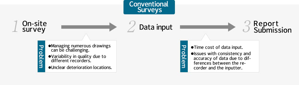
1.Field survey
【Conventional】
The deterioration information identified during the survey is handwritten on drawings or field notebooks.
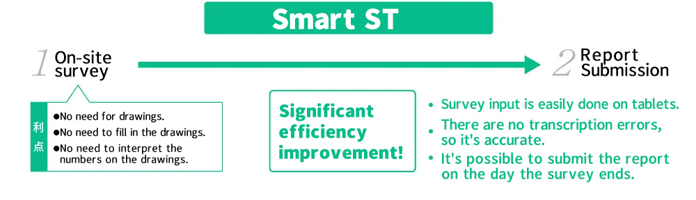
【Smart ST】
Simply input the deterioration information into the tablet app.

2.Report creation
【Conventional】
Entering handwritten char-acters from drawings and field notebooks into a PC while checking.
【Smart ST】
The deterioration infor-mation inputted in the app is saved in the cloud.
3.Report output
【Conventional】
Check for any missing or incorrect numerical entries, ensure accuracy, format it, and then output.
【Smart ST】
Download in the specified report format with just one click from the cloud.
About the features of SmartST
SYSTEM FUNCTION
Capable of adapting to any site with high flexibility specialized for surveys.
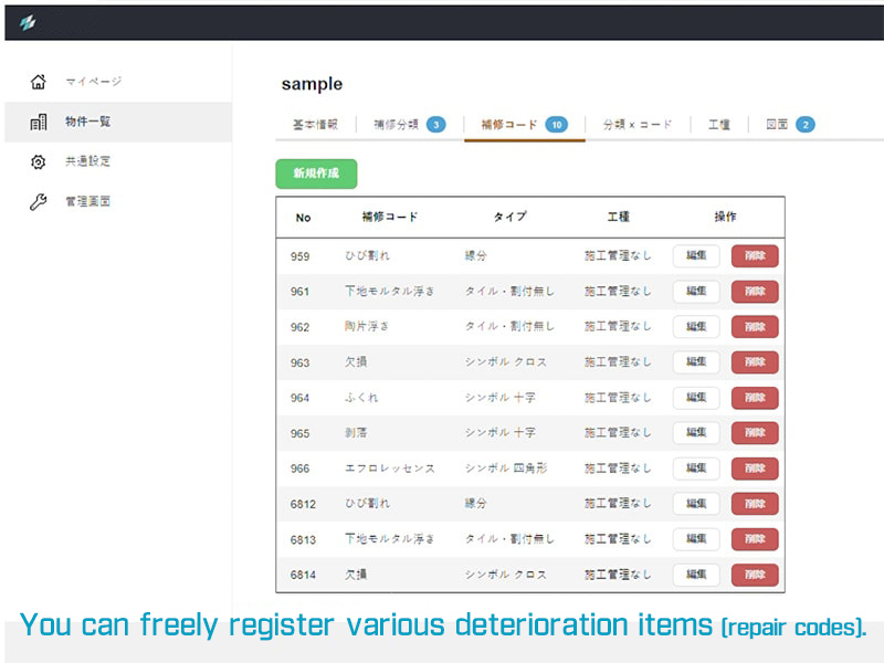
You can customize the survey items required for each site with customizable settings.
In on-site surveys, the types of deterioration, such as crack inspections, tile lifting inspections, and spalling, may vary or be mixed depending on the object under study.
We achieve both ease of surveying and clarity for third parties through high flexibility in types of deterioration, methods of picking up each type, and presentation on drawings.
Easy operation, safe work.
With intuitive controls, anyone can start using it immediately.
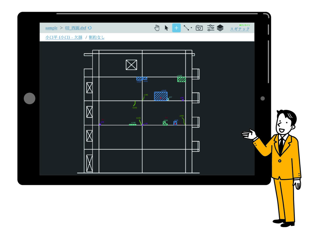
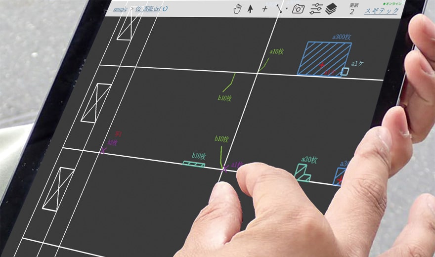
For each site, deterioration information is plotted by tapping on the registered drawings. The various deterioration data entered into the drawings are automatically scaled according to the tile size and drawing scale.
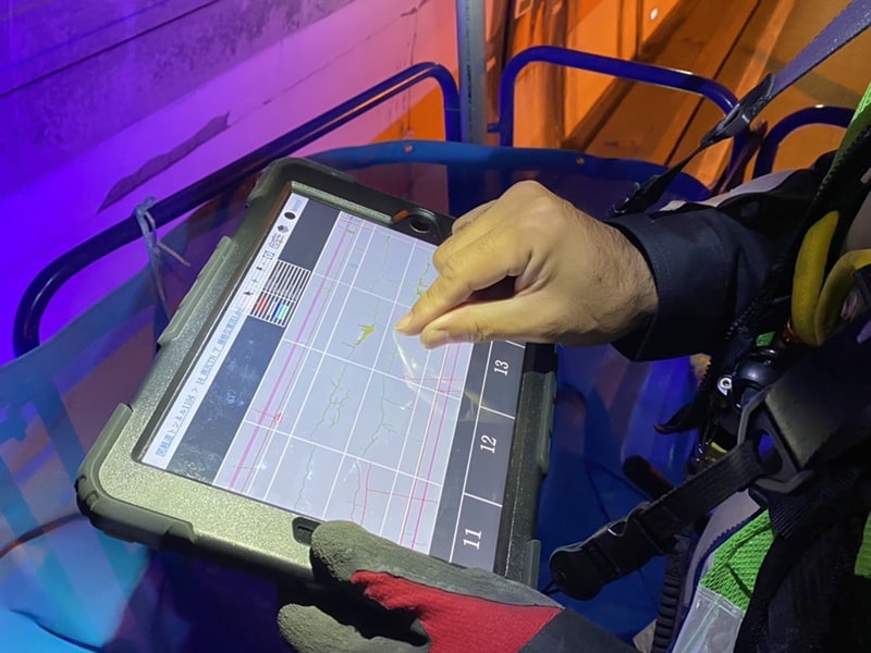
Additionally, the only equipment needed at the site is the tablet. Unlike traditional methods, there's no need for paper drawings, various pens for marking, or a digital camera. This allows for safer work even at high elevations.
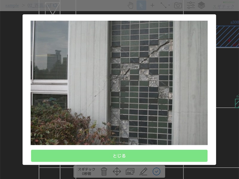
The photos you take are linked to the areas of deterioration.
Photos are always stored and managed in the cloud and can be easily exported to a photo ledger.
Photos of deteriorated areas can be taken with the tablet and inserted directly onto the drawing, linking them to the specific areas of deterioration. Additionally, photos can be added later.
Photos are managed in the cloud and are automatically organized into the prescribed format for photo ledger. You only need to download them from the cloud, significantly increasing efficiency compared to traditional methods.
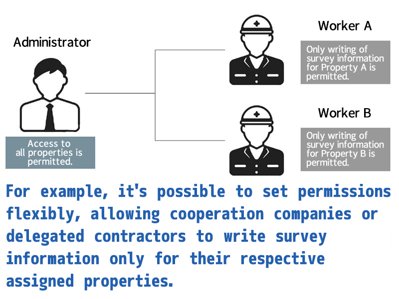
Data can be shared on a per-site basis, with flexible permission settings according to roles.
Progress can be checked anytime, anywhere with cloud data sharing.
The survey data from the site is always synchronized with the cloud, allowing you to check the progress from anywhere at any time.
Furthermore, it is possible to allocate permissions for accessing the cloud to members involved in the site, allowing them to use it according to their roles.
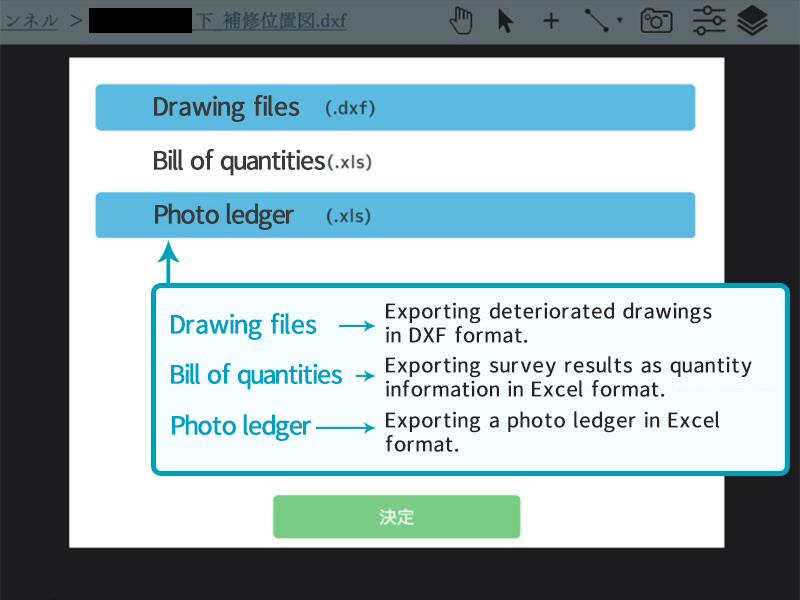
Outputting drawings, quantity lists, and photo ledger is also completed with just one click.
The survey information stored in the cloud can be output in the required format.
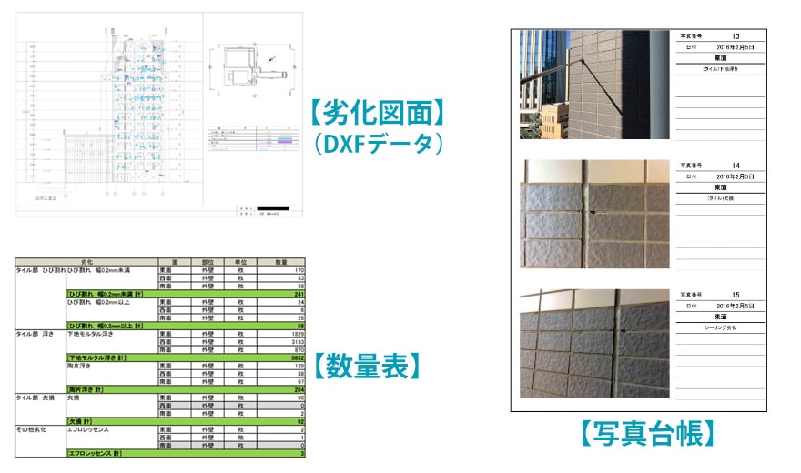
The deteriorated information gathered during the inspection is managed on the cloud, automatically organized into formats for deterioration diagrams, quantity lists, and a photo ledger.
The elimination of transcription from traditional paper drawings significantly streamlines the report generation process. Additionally, with the absence of human error, more accurate data can be provided.
The reasons why SmartST is being appreciated.
We have received favorable evaluations from our client companies.
Point 1
With handwriting eliminated, reports are generated instantly.
In the industry, it's common to manually record deterioration information by hand, leading to variations in handwriting and summarization styles among workers, thus requiring considerable effort to compile reports. However, with the SmartST, conducted on tablets, the efficiency of the process is improved, ensuring accurate numerical data.
The conventional method performed by hand
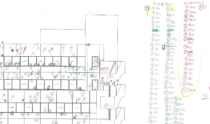
The method of handwritten surveys, which varies depending on the individual, requires transcribing and creating a photo ledger when returning to the office, resulting in a significant personal burden. This approach is still prevalent in the industry.
In the case of tasks performed using the SmartST
With SmartST, inputting deterioration information and taking photos allows for automatic compilation into various formats such as deterioration drawings, quantity sheets, and photo ledger, which can be downloaded from the cloud.
Point 2
Site management becomes smoother.
The status data of the survey work being conducted on-site with SmartST is constantly synchronized in real-time with the cloud server. This means that as long as there is an internet connection, you can check the progress of the work from anywhere through the cloud management interface.
The traditional workflow
You need to separately utilize systems or tools with features that allow progress reporting, which might only be evident in reports after the work is completed.
Using the SmartST
Administrators can simply access the cloud to check detailed work progress whenever they wish.
Point 3
High safety in working at heights
In traditional surveys, multiple colored pens for writing on paper, a digital camera for photo documentation, and a large quantity of drawing sheets are required for the task. Working at heights increases the risk of losing drawings due to strong winds or dropping handheld tools. With Smart ST, only a tablet is needed, making it extremely safe.
Traditional survey methods
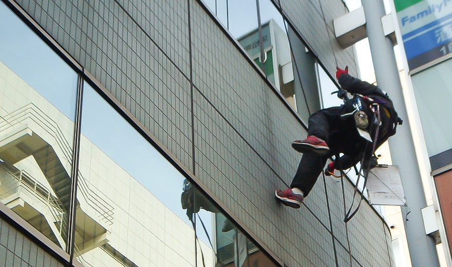
In high-altitude work where pens, digital cameras, and drawings are necessary, attention must be paid to safety.
Using the SmartST
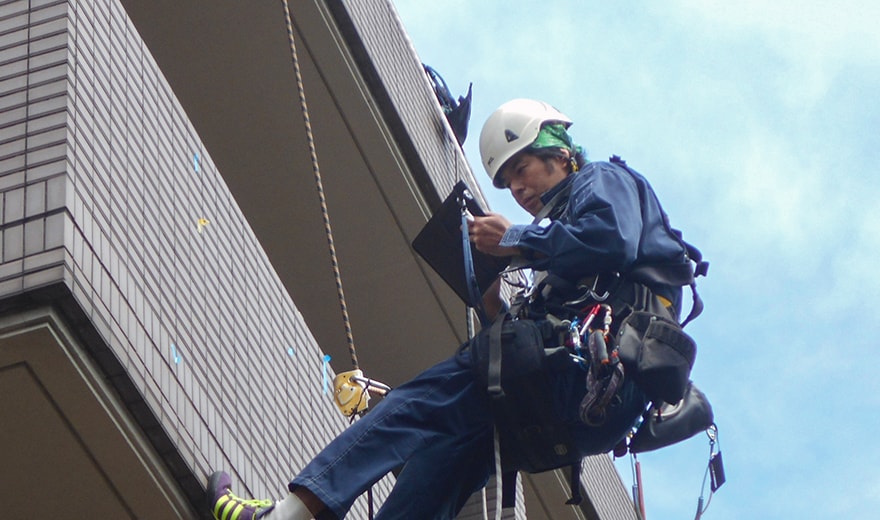
All that's needed is a tablet device with the app installed. Input can be safely done even in unstable environments.
Actual efficiency improvement examples from the field.
Resolves the poor usability and inaccuracy of handwritten records.
Comparison between Smart ST and conventional surveys
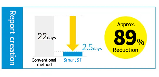
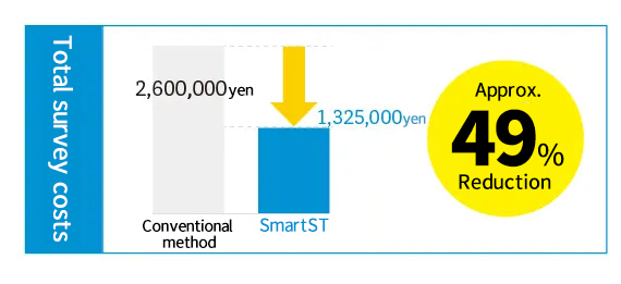
The following is a comparison between the results of Company A, which conducted surveys and report generation using conventional methods, and our company, which utilized Smart ST for the same purposes, in a survey of the interior wall surfaces of a certain subway station (survey area: approximately 3,500 square meters). *The longer survey duration with Smart ST is due to the smaller number of workers compared to Company A.
[Company A]
Survey Method:Sounding rod + Handwritten Field Notes
| Working days | Quantity | Amount | |
| Investigation costs | 13days | 45 | 1,700,000yen |
| Report writing fees | 22days | 33 | 900,000yen |
| Total | 35days | 78 | 2,600,000yen |
Survey Area: Approximately 3,500 square meters >
[Sugitec]
Survey Method:Sounding rod+SmartST
| Working days | Quantity | Amount | |
| Investigation costs | 18.5days | 42 | 1,200,000yen |
| Report writing fees | 2.5days | 2.5 | 125,000yen |
| Total | 21days | 44.5 | 1,325,000yen |
Survey Area: Approximately 3,500 square meters >
The effectiveness of introducing SmartST
To use Smart ST, a separate cloud server is required.
To use the Smart ST application, a dedicated cloud server is required. By using the cloud server, you can access exclusive features such as customizing survey items, linking captured photos, and setting permissions.
Examples of system functions1
Function for creating/registering repair markers
By creating/registering markers for displaying deterioration information and categorizing repairs via the web, they become available for use in the application.
Examples of system functions2
Authorization management function
When using the system on-site, it becomes possible to allocate various permissions for accessing the system's cloud server to the involved members.
Examples of system functions3
Report output function
The inputted deterioration information and captured photos are synchronized and stored on the cloud server. They are organized into various report formats and can be downloaded from the man-agement interface.
Q & A
I have compiled some frequently asked questions for your reference.
PC version
Supported OS:Windows10/Windows11
Recommended browsers: Latest version of Google Chrome/Microsoft Edge
Tablet version
Supported OS:iPadOS14 or later/Android8.0 or later
Recommended spec:iPadAir2 or later/iPadPro(1st generation)or later
※Please note that there may be compatibility issues with certain Android devices, so please inquire for details before use.
CAD software
Recommended software: AutoCAD (R13 or later) / JW-CAD (not compatible with embedded images) / CAD software capable of reading and writing DXF files (R13 or later)
https://www.sugitec.net/smartst/contract/
The specific pricing depends on continued usage or how the service is expected to be utilized by the customer (for example, whether it will be used only for a certain period on a spot basis). Please feel free to contact us for a customized quote.